1. Get the data
Download your county's NFHL data from FEMA's Flood Map Service Center. The flood zones are in the S_FLD_HAZ_AR layer, with the fields FLD_ZONE and ZONE_SUBTY.
 PENTOGIS
Free downloads / Symbology
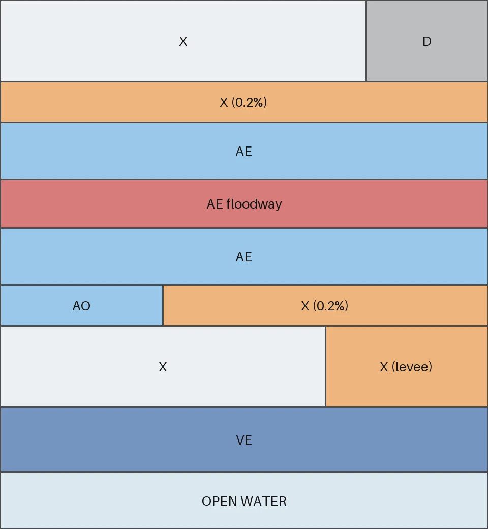
Free styles for FEMA's National Flood Hazard Layer (NFHL): floodways, 1% and 0.2% annual chance zones and coastal V zones, clearly separated and checked for colour-blind readers. Works directly on FEMA's own field names.
Colour table
Click a hex or RGB value to copy it. The styles use these colours at 60% opacity with a dark outline, so streets and labels show through.
| Class | FEMA zones | Hex | RGB |
|---|---|---|---|
| Regulatory floodway | Floodway (usually in AE) | ||
| Coastal high hazard, 1% annual chance (V, VE) | V, VE | ||
| 1% annual chance flood hazard (A zones) | A, AE, AH, AO, AR, A99 | ||
| 0.2% annual chance or reduced risk due to levee (shaded X) | X (0.2 PCT or levee subtypes) | ||
| Undetermined flood hazard (D) | D | ||
| Minimal flood hazard (unshaded X) | X (other) | ||
| Open water | OPEN WATER |
FEMA doesn't publish a single official colour palette for flood zone GIS data. This palette follows FEMA flood map conventions, and the four risk colours pass colour-blind separation checks. For official flood zone determinations, always use FEMA's Flood Map Service Center.
Flood zones explained
Zones starting with A or V make up the Special Flood Hazard Area (SFHA): land with a 1% or greater chance of flooding in any year.
| Zone | Meaning | In SFHA | Shown as |
|---|---|---|---|
| A | 1% annual chance flood area where no base flood elevation (BFE) has been determined. | Yes | 1% annual chance |
| AE | 1% annual chance flood area with base flood elevations shown. | Yes | 1% annual chance (floodway part shown red) |
| AH | 1% annual chance shallow flooding, usually ponding, with average depths of 1 to 3 feet; BFEs shown. | Yes | 1% annual chance |
| AO | 1% annual chance shallow flooding, usually sheet flow on sloping ground, with average depths of 1 to 3 feet; depths shown. | Yes | 1% annual chance |
| AR | Area that will be in the 1% annual chance floodplain until a flood protection system that has been decertified is restored. | Yes | 1% annual chance |
| A99 | 1% annual chance area to be protected by a federal flood protection system under construction. | Yes | 1% annual chance |
| V | Coastal 1% annual chance flood area with wave action (velocity hazard); no BFE determined. | Yes | Coastal high hazard |
| VE | Coastal 1% annual chance flood area with wave action; BFEs shown. | Yes | Coastal high hazard |
| X (shaded) | 0.2% annual chance flood area, 1% annual chance flooding with average depths under 1 foot or drainage areas under 1 square mile, or areas protected from the 1% flood by a levee. | No | Shaded X |
| X (unshaded) | Minimal flood hazard, outside the 0.2% annual chance floodplain. | No | Minimal |
| D | Flood hazard possible but not determined. | No | Undetermined |
Downloads
How to use it
Download your county's NFHL data from FEMA's Flood Map Service Center. The flood zones are in the S_FLD_HAZ_AR layer, with the fields FLD_ZONE and ZONE_SUBTY.
Open Layer Properties → Symbology → Style → Load Style and pick fema-flood-zones.qml. It's a rule-based style, so floodways are picked out of AE zones automatically.
Run Apply Symbology From Layer with fema-flood-zones.lyrx. It classifies with an Arcade expression, included as a text file if you'd rather paste it into your own style.
Upload fema-flood-zones.sld. Its rules don't overlap, so a floodway is drawn once, in red, not on top of its AE colour.
Use the CSV or JSON table. Classify floodways first, then V and VE, then the other A zones, then X by subtype.
Load fema-flood-zones-sample.geojson and apply a style. It should match the preview, including the floodway and the levee area.
Good to know
A 1% chance of flooding in any given year, often called the "100-year flood". It isn't once a century: over a 30-year mortgage, the chance of at least one such flood is about 26%.
The regulatory floodway is the stream channel plus the nearby land that must stay open to carry the base flood. Development there must not raise flood heights, so it faces the strictest rules.
Lenders require flood insurance for federally backed mortgages on buildings in the Special Flood Hazard Area (zones A and V). It's optional, but often worthwhile, in zone X.
FEMA's maps show both as shaded zone X: moderate risk, outside the Special Flood Hazard Area. Levees reduce risk but don't remove it.
No. Use FEMA's official maps or a flood zone determination. These styles are for planning and communication maps.
Planning for flood risk?
Flood zones, depths, parcels and people, combined into maps and numbers for plans and grant applications.