QGIS
Open Layer Properties → Symbology → Style → Load Style and pick nlcd-land-cover.qml. Or set the renderer to Paletted/Unique values and load nlcd-land-cover-qgis-colormap.txt.
 PENTOGIS
Free downloads / Symbology
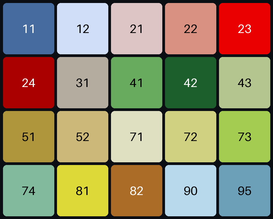
The standard legend colours of the National Land Cover Database (NLCD) as styles for QGIS, ArcGIS Pro, GeoServer and Google Earth Engine, with a colour table you can copy from and a sample raster to test.
Colour table
Click a hex or RGB value to copy it. The first digit of each code is its group: 4x is forest, 8x is farmland, and so on. Four classes occur only in Alaska.
| Code | Class | Group | Hex | RGB |
|---|---|---|---|---|
| Water | ||||
| 11 | Open Water | Water | ||
| 12 | Perennial Ice/Snow | Water | ||
| Developed | ||||
| 21 | Developed, Open Space | Developed | ||
| 22 | Developed, Low Intensity | Developed | ||
| 23 | Developed, Medium Intensity | Developed | ||
| 24 | Developed, High Intensity | Developed | ||
| Barren | ||||
| 31 | Barren Land (Rock/Sand/Clay) | Barren | ||
| Forest | ||||
| 41 | Deciduous Forest | Forest | ||
| 42 | Evergreen Forest | Forest | ||
| 43 | Mixed Forest | Forest | ||
| Shrubland | ||||
| 51 | Dwarf Scrub Alaska only | Shrubland | ||
| 52 | Shrub/Scrub | Shrubland | ||
| Herbaceous | ||||
| 71 | Grassland/Herbaceous | Herbaceous | ||
| 72 | Sedge/Herbaceous Alaska only | Herbaceous | ||
| 73 | Lichens Alaska only | Herbaceous | ||
| 74 | Moss Alaska only | Herbaceous | ||
| Planted/Cultivated | ||||
| 81 | Pasture/Hay | Planted/Cultivated | ||
| 82 | Cultivated Crops | Planted/Cultivated | ||
| Wetlands | ||||
| 90 | Woody Wetlands | Wetlands | ||
| 95 | Emergent Herbaceous Wetlands | Wetlands | ||
These are the standard NLCD legend colours from USGS and the Multi-Resolution Land Characteristics (MRLC) Consortium, checked against a second published copy of the legend.
Downloads
How to use it
Open Layer Properties → Symbology → Style → Load Style and pick nlcd-land-cover.qml. Or set the renderer to Paletted/Unique values and load nlcd-land-cover-qgis-colormap.txt.
Run the Add Colormap tool (Data Management) with nlcd-land-cover.clr to attach the colours to your raster.
Upload nlcd-land-cover.sld. It uses an exact-value colour map, so each code gets its colour and nothing is blended.
NLCD codes aren't consecutive, so remap them to 0–19 first, then use the palette. The snippet below does both.
Use the .clr file with gdaldem color-relief -exact_color_entry to make a coloured GeoTIFF.
Open nlcd-sample.tif. Its colours are built in, so it should look like the preview straight away. Then apply a style to check it matches.
// NLCD land cover palette for Google Earth Engine (values 11-95)
var nlcdValues = [11, 12, 21, 22, 23, 24, 31, 41, 42, 43, 51, 52, 71, 72, 73, 74, 81, 82, 90, 95];
var nlcdPalette = ['466b9f', 'd1def8', 'dec5c5', 'd99282', 'eb0000', 'ab0000', 'b3ac9f', '68ab5f', '1c5f2c', 'b5c58f', 'af963c', 'ccb879', 'dfdfc2', 'd1d182', 'a3cc51', '82ba9e', 'dcd939', 'ab6c28', 'b8d9eb', '6c9fb8'];
// Remap to 0..19 and display:
// var lc = image.remap(nlcdValues, ee.List.sequence(0, 19));
// Map.addLayer(lc, {min: 0, max: 19, palette: nlcdPalette}, 'NLCD');
Good to know
The National Land Cover Database is a 30 m land cover map of the United States from the USGS and its MRLC partners, made from Landsat imagery. Each pixel holds a class code such as 41 (deciduous forest) or 82 (cultivated crops).
The codes are two digits: the first is the group (1 water, 2 developed, 4 forest and so on) and the second the class within it. Unused numbers are simply skipped.
51 Dwarf Scrub, 72 Sedge/Herbaceous, 73 Lichens and 74 Moss. Maps of the lower 48 states use the other 16.
Reproject class rasters with nearest-neighbour resampling. Bilinear or cubic resampling averages codes and creates classes that don't exist.
Not fully. Several greens and browns are hard to tell apart. For public maps, add a clear legend and consider merging classes into fewer groups.
Mapping land cover?
Land cover maps, change between years, and area by class for your area.